Skip to content
Menu
BASICS
Introduction
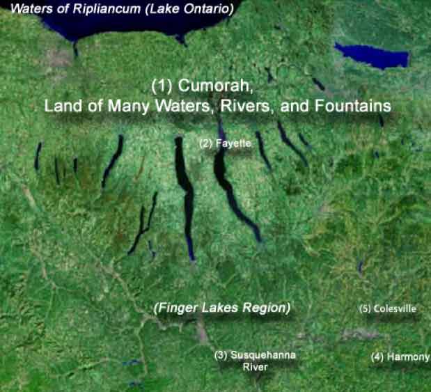
Western New York Model
Hidden
Lamanites
Writing
Elephants
Horses
Errors
Errors 6-10
Errors 11-15
Errors 16-20
Errors 21-23
Errors 24-25
Facts
Anti-Mormon
Evidence
Cumorah
Deception
PSI
New Jerusalem
Test
Seas
Boundaries
Fringe Theory
Geographical Priority Index – GPI
Prerequisites
Fringe Theory
Moratorium
Names
Prerequisites
Sacred Geography
LANDS
Old World
Lands Changed
Land Changed – Land Northward
Land Changed – Land Southward
Land of Cumorah
Giants
Omer
Church Canon
Church History
Oliver Cowdery
David Whitmer
William B. Smith
Lucy Mack Smith
Parley P. Pratt
Orson Pratt
Brigham Young
1879 Book of Mormon
George Albert Smith
James E. Talmage
Anthony W. Ivins
J. M. Sjodahl
Mark E. Peterson
Joseph Fielding Smith
John A. Widtsoe
Bruce R. McConkie
E. Cecil McGavin
Riley Lake Dixon
Marion G. Romney
Gordon B. Hinckley
Brenton G. Yorgason
Bishop’s Letter
Bruce E. Dana
Sidney Sperry
William J. Hamblin
Martin H. Raish
ASH BASH
BRANT CAN’T
CAPTAIN KIRK
John E. Clark
HEDGES PLEDGES
Rex C. Reeve Jr., Cumorah, Hill
Rex C. Reeve, Jr. and Richard O. Cowan
TVEDTNES’ RESISTANCE
Land Northward
Land Desolation
Poisonous Serpents
Cement Houses
Logging
Elephants
Mountains
Land Changed
Coming of Jesus
Land Southward
River Sidon
Mississippi River
Two Sidons
Zarahemla
Sidon Maps & Pictures
Hill Amnihu
Hermounts
Mountains
Land of Nephi
Others
Lamanites
Land of Nephi – Where?
Limhi Expedition Route
Amlicites
Ammon
Ammonihah
Lamanite Line of Possession
Land of First Inheritance
City & Land Bountiful
Archaeological Evidence
Line Bountiful
Narrow Neck of Land
Niagara Strip
Lake Tonawanda
Not Batavia Moraine
Black Rock Pier
MODELS REVIEWED
Book of Mormon Archaeological Forum
Critical Criteria for Identifying the New World Lands of the Book of Mormon by Ted Dee Stoddard
Thick Darkness, Vapor of Darkness, and Mists of Darkness: Indications of Weather and Climate in the Book of Mormon by Ted Dee Stoddard
Whiteness of the Driven Snow: An Evaluation of the Word Snow in the Book of Mormon by Ted Dee Stoddard
Brief History of the Limited Geographic View of the Book of Mormon by John A. Tvedtnes
Book Mormon Central
Kirk Magleby
Heartland Model
Heartland Research Group
Jonathan Neville
Rian Nelson
Rodney Meldrum
Wayne May
H38 Virus
Joseph Allen
Duane R. Aston
J Theodore Brandley
Norman David Brockenshire
Stephen Carr
Randal S. Chase
C. W. Clark – RLDS
John E. Clark
W. Vincent Coon
Delbert W. Curtis
Thomas Stuart Ferguson
Joshua B. Mariano & Edwin Goble
William J. Hamblin
Scott Hamilton
Joel Hardy
Dr. F. Richard Hauck
Paul Hedengren
Vernal Holley
P. Douglas Kiester M.D.
John Lund
Wayne May
Chet Meek
Rodney Meldrum
Alan Miner
Just Marlene Newell
V. Garth Norman
Phyllis Carol Olive
Ralph Olsen
L. H. Pearson, Ph.D.
Eugene L. Peay
Lawrence Poulsen
Joel Ricks
Lynn Rosenvall & David Rosenvall
Patrick L. Simiskey
John Sorenson
Aric Turner
UFT36
James Warr
J. A. Washburn
John W. Welch
Christ in America Foundation
Journey of Faith: The New World
LDS Organized Products
Reflections With Christ, Another Testament
RLDS
Aric Turner
John Sorenson
John Clark
John Lund
Edwin M. Wooley
J. Theodore Brandley
R. A. Olsen
Norman David Brockenshire
Vaughn E. Hansen
RIVERS
River Sidon
Sidon Maps & Pictures
Two Branches
Mississippi River
Ablom
SEAS
Great Deep
West Sea
Sea North
East Sea
Sea South
MAPS
World View
Old World
New World
Land Northward
Land of Desolation
Narrow Neck of Land
Land of Cumorah
Land Southward
Land of Bountiful
Land of Zarahemla
Land of Nephi
Land of Ishmael
Other Maps
Deluge Map
Lines: Bountiful, Defense, Lamanite
Mormon’s Life – The Final Lead Up
Seas
Spiritual
TOPICS
Ablom
Amazing
Ammon
Ammonihah
Amlicites
Ancient Forests
Animals
Bones
Cement
Cities
Clothing
Distances
DNA – Hagoth
Elephants
Flint
Fortifications
Fringe Theory
Geology
Gentiles
Gold
Herbs
Hidden
Horses
Jershon
Lamanites
Limhi
Mounds
Names
Naturists
Ontario Prehistory
Others
Pass
Plains
Population
Shipping
Size
Temples
Trails
Trees
Walls
Weather
Writing
Wilderness Side
PROPHECIES
Gentiles
New Jerusalem
The New Jerusalem is Already Here
New Jerusalem Facts
The Book of Mormon and the Constitution
American Exceptionalism
Misguided Zeal
Spiritual Geography
Bible
DC 10
Lehi – Prophecy Of
Nephi – Prophecy Of
Jacob – Prophecy Of
2nd Nephi
3rd Nephi
Mormon
USA
Prayer of the First Continental Congress – 1774
BOOKSTORE
RESEARCH
Book of Mormon Geography Lands - Western New York Model
Home
>
vincent-coon
vincent-coon